GLOBALVARS
0
Among hurricane watchers, “I” is the scariest letter in the alphabet. Since 2001, the ninth named storm of the year in the Atlantic Basin — which usually arrives around the mid-September peak of the season — has historically been the worst of the worst. Ida. Irma. Ivan. Isabel.
This year, there might not be enough storms for “I” ever to become a threat. With just eight to 14 named storms expected, the 2026 Atlantic hurricane season could very well conclude with the formation of Tropical Storm Hanna.
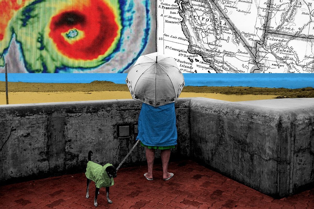
The Eastern Pacific season, however, is a different story. Having already ticked off Amanda, Boris, and Cristina since its season started on May 15, the basin could blow past “I” — also its most retired initial — and go as deep as Xavier, the 22nd name on this year’s list. And the more storms there are in the Eastern Pacific, the more chances there are for a “gray swan” event — in this case, the historically unheard-of but scientifically possible impact or even landfall of a hurricane in California.
“We know there’s a chance, but because of the rarity in the historical record, particularly in the recent 100 years, people lack understanding of this type of event,” Laiyin Zhu, a climate scientist at Western Michigan University and the co-author of a new paper in Nature Climate Changeabout the increasing risk of cyclone-related impacts on southern California, told me.
Blame El Niño for all the fuss this year. The National Oceanic and Atmospheric Administration formally announced its return last week, and though the atmospheric phenomenon has the effect of suppressing hurricane formation in the Atlantic basin by increasing wind shear and knocking would-be hurricanes off-kilter, the case is different on the left coast. Record and near-record warm waters serve as an engine for the cyclones that form in the Eastern Pacific, a pocket that extends as far as the 140th meridian west, an otherwise obscure latitude that cuts south from Alaska’s Yakutat Bay into the open ocean.
And there is no relief in sight: “With global warming in the next several decades, we are expecting a strong increase of sea surface temperature with the magnitude of about 2.7 degrees Celsius, and this will provide a lot of energy to the tropical cyclones on the East Pacific side of the state,” Zhu said.
Though about as many hurricanes form on average in the Eastern Pacific as in the Atlantic, trade winds push storms in the latter basin westward toward the Caribbean nations, Latin America, and the southeast and eastern United States, sparking excitement, attention, and the odd scandal when they threaten population centers. Storms in the Eastern Pacific follow the same westward trajectory, sometimes bumping into coastal Mexico, though just as often drifting harmlessly out to sea. In rare cases, a steering pattern sends a storm due north toward San Diego or Los Angeles. Each time that’s happened, cold waters off Southern California have starved the cyclone of its warm-water fuel before it can make landfall at full hurricane strength.
In an above-average Eastern Pacific hurricane season such as this one, however, there are more opportunities for a storm to follow that rare track toward California. Additionally, during an El Niño year, Southern California’s protective cold-water barrier becomes slightly warmer, meaning the continent has less protection against tropical storms that take the road less traveled by. To wit: The closest a hurricane has ever come to making landfall on the state was in 1852, an El Niño year. Hurricane Hilary, which prompted the National Hurricane Center to issue its first-ever tropical storm warning for Southern California in 2023, also formed during an El Niño. Though that storm weakened to below the tropical storm threshold before making landfall, its remains dropped more than half a year’s average rain on many parts of the region, killed one person, and racked up some $900 million in flood- and mudslide-related damage.
This year, Southern California will be all the more vulnerable due to the 60% chance of a “super” El Niño forming. “This, on top of the gradually increasing [sea surface temperature] from the climate background, is going to increase the probability of tropical cyclones making landfall, potentially with this rainfall and landslide impact over California,” Zhu said.
Realistically, the danger to California isn’t a Category 5 hurricane making landfall; if a tropical storm were to reach the shores of the western U.S., it’d very likely be weak and unstable. Rather, as Zhu and his colleagues’ research has found, the threat in a high-emissions warming scenario is that the warming Eastern Pacific shortens the return period of a “Hurricane-Hilary-magnitude rainfall” by 50%, from 110 years to 54 years.
While more rain for the drought-plagued Southwest might sound like a good thing, “we are talking about a so-called whiplash event,” Zhu told me. “If we have severe drought followed by a severe rain event, it is going to create big disasters like landslides because the dry soil is not going to absorb the rainfall in a short time efficiently.” The researchers found that all Southern California counties “exhibit growth in areas exposed to landslides from 2000 to 2050,” though the risk is disproportionate; for households earning less than $50,000, landslide risk could triple by the middle of the century compared to wealthy households, where it will increase by less than half. (Wildfires in the region have also made the landscape particularly prone to mudslides since the loss of vegetation disrupts normal water absorption by the soil and makes slopes more unstable after rain.)
There might be a spot of good news, though. Jin-Yi Yu, a professor of earth system science at the University of California, Irvine, told me that while he had not read the Nature Climate Change article, he thinks California might at least be spared a winter deluge of the likes of the 1997-1998 El Niño, which ran the state some $850 million in storm-related damage.
Often a skeptic of “super El Niño” hype, Yu acknowledged that this year appears headed toward the superlative. But as his research has shown, using the historical record to predict El Niño has become increasingly unreliable since the 20th century due to its shifting center and marine heatwaves. So far, the patterns in 2026 look more similar to the 2015-2016 El Niño, which was the strongest on record, but also developed a warm-water pocket near the International Date Line that disrupted the system to the point that winter rainfall in California was actually below average.
But if California dodges both a hurricane and a record-wet winter this year, that makes the state lucky, not invincible. Californians “are not like people from Florida, who are always getting hit by hurricanes and who know how to evacuate and how to build their houses to a certain standard,” Zhu said. Californians are particularly vulnerable to tropical cyclones because they’re so unlikely. Policymakers should be thinking now about zoning changes in landslide-prone areas and home-hardening measures in anticipation of when the “grey swan” event finally arrives.
“I hope this doesn’t happen this year, or for many years, in California,” Zhu said. “But we need to be aware of it.”